Determination of lot area, orientation, width, and depth is necessary for several Planning- and Building-related actions. For example, a lot is only considered a “standard lot” if it meets the minimum requirements of the zoning district in which it is located. Lot area and dimensions are also used as a basis for common development requirements, such as floor area, and some required building setbacks are based on a percentage of the minimum lot width. Similarly, a lot may be subdivided only when the new parcels qualify as standard lots (except as allowed by SB 9).
Please see the City’s GIS Map Viewer to determine which zoning district a particular parcel is in, and review the Zoning Ordinance to determine the minimum area, width, and depth requirements for that zoning district.
In most cases, the measurements and determinations will be clear, but in some cases, the lot line(s) or other property attributes are irregular. In such cases, please check with the Planning Division for a formal determination, which will be logged in City records for future reference.
Lot area is the area of a horizontal plane between the bounding lot lines, expressed in square feet. The City's GIS Map Viewer can provide approximate lot size data, derived from county assessor’s maps, although note that a boundary survey will ultimately provide the most accurate calculation of the area of a lot. Boundary surveys are required by the City for most discretionary projects (i.e., those requiring Planning Commission review), and for building permit projects when the proposed addition is more than 500 square feet or within one foot of a required setback. Other conditions may apply. Please see the Boundary and Topographic Survey Requirements handout for more information.
Per Zoning Ordinance Section 16.04.314, neither private driveways or access easements across another lot to a panhandle lot, nor panhandle extensions of panhandle lots, are included as part of the lot area to determine the floor area limit (FAL). Per Zoning Ordinance Section 16.59.020, for the purpose of determining minimum lot size and the number of units to be constructed on a particular building site, the Planning Commission shall have the discretion to include or exclude any portion of such building site occupied by any easement, depending upon the extent to which it impairs the use of the property.
The orientation of a lot is defined by the ordinances and definitions described and diagrammed below. Please note for corner lots: the orientation of a residence on such lots (i.e. the front door of the residence and/or the mailing address), does not always align with the front property line as defined by the Zoning Ordinance and should not be used to determine the lot orientation.
Front Lot Line
Per Zoning Ordnance Section 16.04.400, the front lot line is:
- In the case of an interior lot fronting on a public street, a line separating the lot from the public street,
- In the case of an interior lot fronting on a private street, but not on a public street, a line separating the lot from the private street,
- In the case of a corner lot fronting on two public streets, a line separating the shorter street frontage of the lot from a public street,
- In the case of a corner lot fronting on one public street and one private street, a line separating the street frontage of the lot from the public street,
- In the case of a corner lot fronting on two private streets, but not on a public street, a line separating the shorter street frontage of the lot from a private street, and
- In the case of a panhandle lot, the shorter dimension of the lot boundaries which are contiguous to the private driveway or easement which provides access to the lot
Rear Lot Line
Per Zoning Ordinance Section 16.04.440, the rear lot line is the lot boundary opposite or approximately opposite the front.
Side Lot Line
Per Zoning Ordinance Section 16.04.450, a side lot line is defined as any boundary not classified as a front or rear lot line.
Example diagrams
| "Corner lots" (ZO 16.04.395) have frontages on two public or private streets which intersect at a corner of the lot. |
|
| "Through lots" (ZO 16.04.460) have frontages on two parallel or approximately parallel streets |
|
| "Panhandle lots" (ZO 16.04.455) are those with little or no frontage on a street and to which the access is by easement or private driveway, and can vary in orientation depending on the length of the lines that touch the access extension (or easement). |
|
| Many lots are rectangular, making the determination of Front/Rear/Side clear, although others are irregular in shape and may require consultation with the Planning Division to confirm their precise orientation and lot lines. |
|
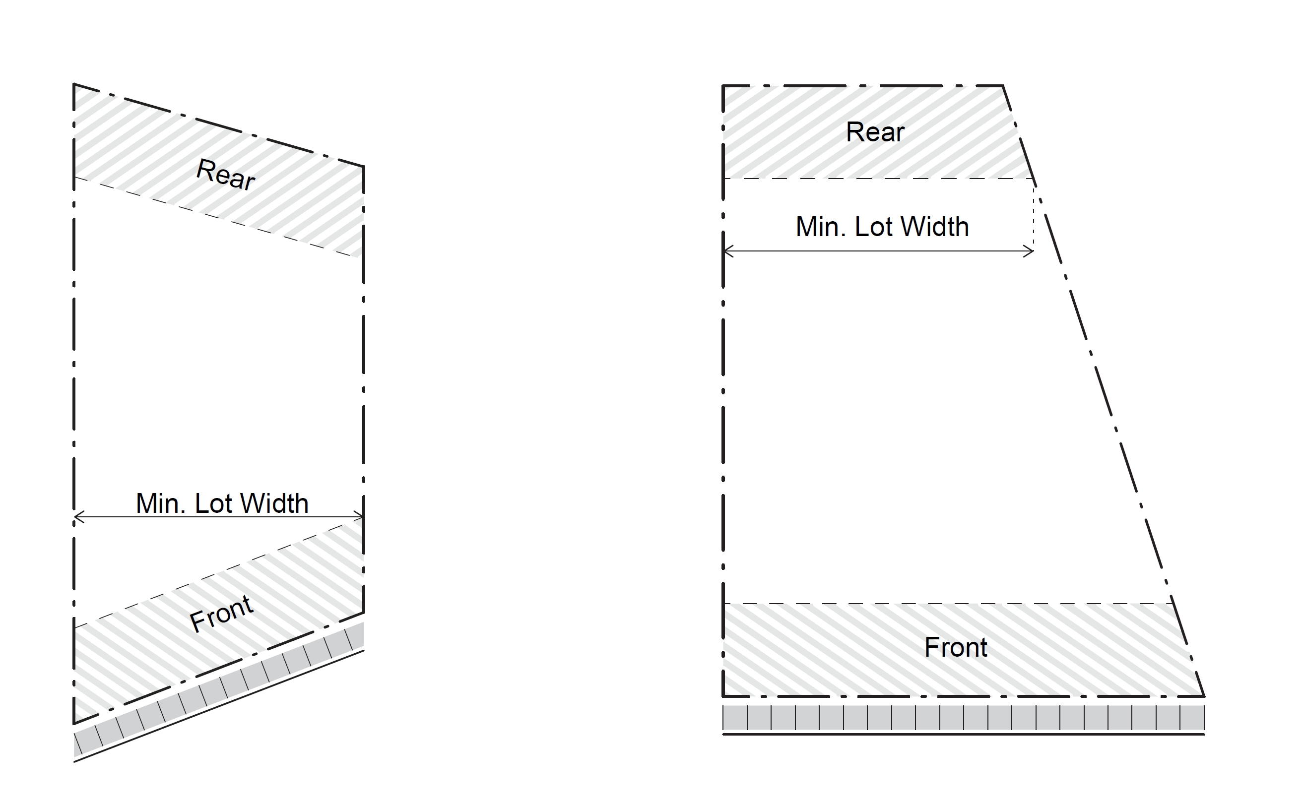
Per Zoning Ordinance Section 16.04.430, the “minimum width of lot” means the shortest distance between the side property lines, between the required front and rear setback lines. To determine the minimum lot width:
- Draw the front and rear setbacks per the applicable zoning district. A setback line is “a line established to govern the placement of buildings or structures with respect to lot lines on the site and which is established by measuring from the lot lines and/or access easements on the site at an angle perpendicular to the lot line. The setback line shall be parallel with the lot line.”
- Draw a line between the front and rear setbacks at the point where the width of the lot from side property line to side property line is the most narrow; this is the “minimum lot width” line.
In the example below left, although the front/rear property lines are not parallel, the side property lines are. Therefore, the minimum lot width is a perpendicular line connecting the sides in the area between the front and rear setbacks.
In the example below right, the lot is most narrow at the rear setback, and as such, the minimum lot width dimension would be measured at the rear setback.
|
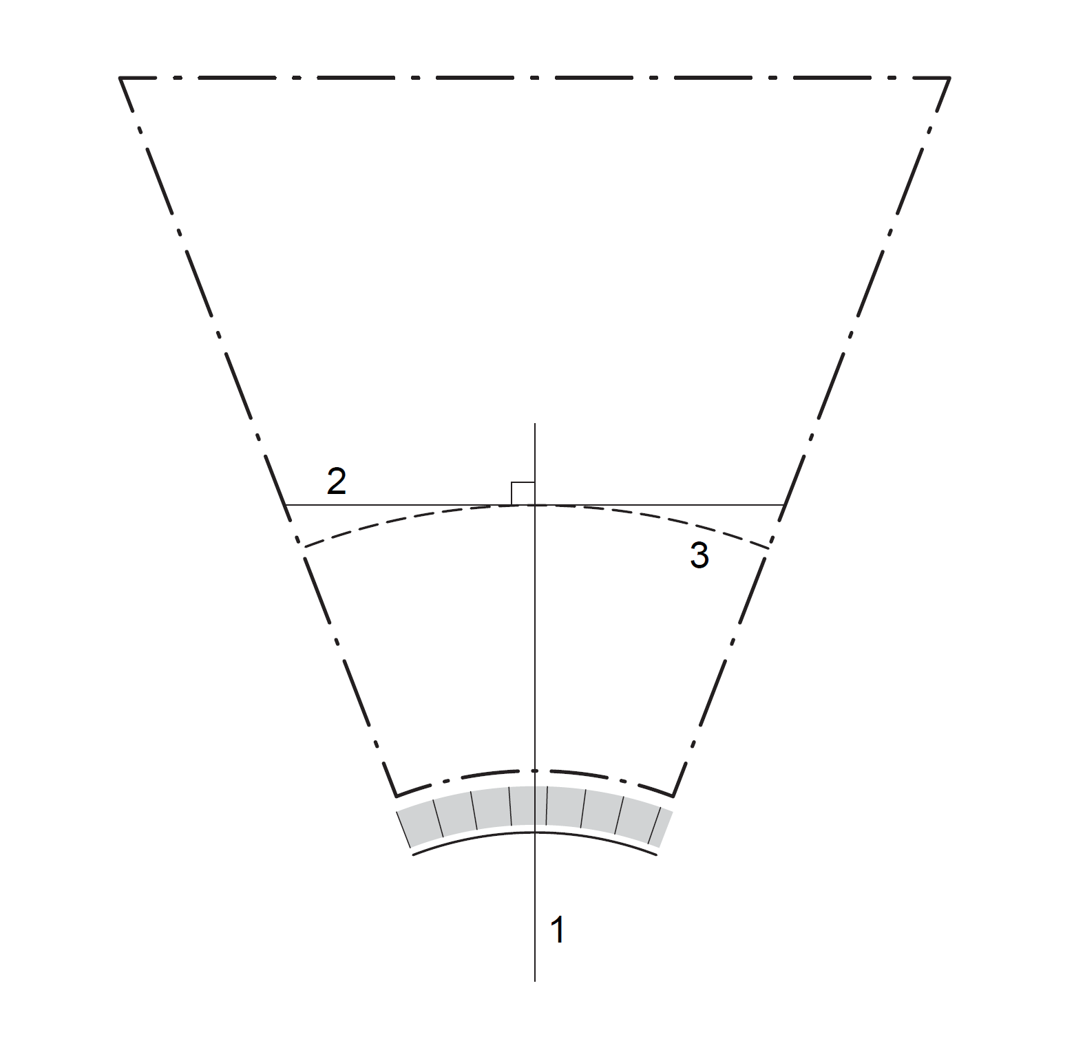
With regard to front setbacks, most parcels have a set requirement as established in the respective zoning district. However, where lot frontage abuts the outside of any curve of a radius of 100 feet or less, the front setback may be greater, as the example below generally shows. See the Subdivision Ordinance Front Setback handout(PDF, 174KB) for more information.
|
 |
Per Zoning Ordinance Section 16.04.420, “minimum depth of lot” means the average distance between the front and rear property lines.
In the case of an irregularly shaped lot, the average distance is determined through the following process:
- Divide the front and rear property lines to create eleven (11) equally-distanced points across the lot (including the endpoints of each line).
- Connect the points on the front property line to the corresponding point on the rear property line and measure the eleven distances between the front and rear property lines.
- Average the eleven distances to find the minimum depth. In the example below, the average is 104.63 feet, a standard depth for the R-1-U zone.